Maps
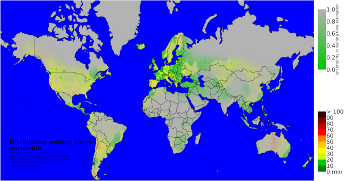
- Looking for Map of Hitchhiking spots instead?
Maps are essential to hitchhiking. Make sure you always have a good map with you, the scale should at least be 1:700.000. In Western Europe and a few other countries it is very important to have a map that shows petrol stations, service areas, toll gates and other important places on the motorways. A map with a scale of 1:250.000 will still allow you to recognize enough details to walk somewhere if you get lost.
You want to know were you are going. It also helps if petrol stations are marked, and you don't need city maps. Try and find a map that you don't have to open out to one large sheet of paper every time you want to use it; you will be using it often. Book-style maps are best.
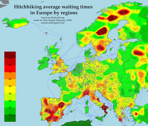
Hitchhiking maps
2024
Originally published here.
2019
Originally published here.
Online maps
Hitchhiking
- hitchmap.com Wordwide map of hitchhiking spots with wainting times and comments. Can be downloaded as .gpx file for offline use.
- Tank & Rast A map of service areas along the highways in Germany.
Standard maps
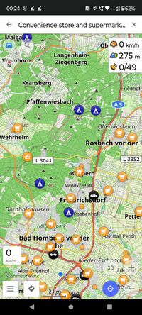
- OpenStreetMap Free and open map that is created by volunteers. Can be used online or offline via apps:
- Organic Maps Free, open-source fork of maps.me. Pretty easy to use.
- Google Maps StreetView can be good to check for hitchhiking spots. Very limited offlince capability.
- Yahoo Maps
- Bing (Microsoft).
- map24 Map for South America.
Shelters, (Wild)camping
Various free map data sources are available which are useful for the modern hitchhiker. Here is a list of website which provide such data:
- refuges.info - wilderness huts database, mostly in France and Alps region
- pyrenees-refuges.com - wilderness huts in Pyrenees mountain range
- campwild.com - Community/volunteer based map of shelters and wildcamping spots with pictures and comments. Spots can be dlowloaded for offline use as .gpx and .kml. Most entries for Sweden and Germany but plenty of other countries have at least some spots listed.
- sydsverige.dk - shelters in Sweden
- [1] - campsites/shelters/fireplaces in Sweden
- [2] - campsites/shelters/fireplaces in Sweden
- tulikartta.fi - camping and wilderness huts in Finland
- laavu.org - wilderness huts in Finland
- freecampsites.net - worldwide free campsites database
- boudy.info - czech republic and slovakia (mostly) shelters
- tourenwelt.info - worldwide hut data (in german)
- mountain-huts.net - mountain huts in the balkans (Slovenia, Croatia, Bosnia, Serbia, Montenegro, Greece, Macedonia, Bulgaria)
- bivakzone.be - campsites in belgium
- udinaturen.dk - campsites in denmark
- rmk.ee - campsites and huts in estonia
- google.com/maps - free camping in Japan
- hatinosu.net - free camping & hot springs in Japan
- doc.govt.nz - government huts in new zealand
- ifreecamp.com Free campsites in Israel.
- 1nitetent.com People offering a free camping spot. Most ask to be contacted (mail, phone, whatsapp) ahead.
- a map created with google maps Shelters in Norway
Hospex/Couchsurfing
Nice people offering their home or a spot in the garden. The ones listed here provide a map search that let's you easily for more remote spots or to search e.g. for spots near onramps/highways/etc.
- trustroots.org
- BeWelcome.org
- couchers.org
- warmshowers.org Intended for cyclists, so maybe more for the hitchbikers out there.
- 1nitetent.com People offering a free camping spot. Most ask to be contacted (mail, phone, whatsapp) ahead.
Offline maps
The following maps can be used (at least) partially offline:
- hitchmap.com All spots can be downloaded as a .gpx file and imported/viewed in many map apps (e.g. OsmAnd)
- OpenStreetMap Apps like OsmAnd or Organic Maps let you download various map data. For OsmAnd you can download:
- complete map /road-only map for a city/region/country
- geocoded wikipedia articles (great as a travel guide) for a city/region/country
- wiki voyage data, a non-commercial wiki-style travel guide
- satellite view (selected as overlay map) can't be directly downloaded but will be cached and available for offline use
- campwild.com All spots for the selected countries can be downloaded as .gpx or .kml files for use in your map app.
There are a few ways to use Hitchwiki maps and spots offline.
Paper maps and Atlas
Local Maps
Remember that petrol stations often have maps for sale, including very local ones. If you need to find out the geography of the local area, simply walk into the shop, pick up a local map, study it, get the information you need, then put it back and walk out. Many service stations also have large maps on walls or notice boards. Other local maps can often be found on public transportation stations and on the backside of free-standing advertisements in bigger cities. You can just take a picture of them with a digital camera or smartphone if you need to look something up later; check if the picture is sharp enough.
The following section contains maps for whole continents, series of country maps for a continent and maps that only exist for particular countries.
Europe complete
Recommended
- The Shell Euroatlas is good for Europe, however, it's difficult to find.
- Collins Road Atlas: Europe 200 (1 : 1 000 000) is nice and has most petrol stations, even though it is a bit large (A3).
- The Berlitz Europe atlas includes petrol stations and has a ratio of 1:800 000, though many important cities are in the crease of the book and are difficult to read (e.g., Paris, Berlin, etc.).
- A good map I've found (it has petrol/service stations marked and it's really small and handy! just a little bit bigger than a lonely planet guide) is the 1:1.250.000 Atlante Stradale Europa edited by Istituto Geografico De Agostini (ISBN 88-511-0968-0), it's sold in italian book shops but can be found on amazon as well.
- For Western, Northern and Southern Europe: one specific edition of the Marco Polo car map of Europe is great, it doesn't contain too much useless stuff like indices or city maps, and shows petrol stations on highways! Unfortunately guakasite, wikitalk only found this one in Slovakia. This map could also be found in Germany, Czech Republic and Poland - Tom has a copy of both Czech and Polish editions (both editions exactly the same but with different front cover), and he bought these in 2006. They are still the best hitchhiking maps he's seen - hopefully the more modern editions are still as good. The cost was around 10 euro.
- Philip's compact atlas Europe shows service stations in some countries, is pretty compact and was available for 7 euro at the New English Book Store in Amsterdam, in June 2008.
- Falk Europa Transportatlas (2006, ISBN 9789028723115 - sample), European countries at 1 : 800 000 in an A4 ring binder. Features service stations. Legend in all European languages and traffic glossary in Europe's main languages. Be advised the atlas weighs significantly more than average: 1,5 kg. You could save about 300 gr if you remove the NL pages Landendocumentatie.
Europe country map series
Recommended
- The Falk Länderkarte series (in German, but can be understood by everyone) is brilliant for individual European countries, with a useful, clever and compact fold-out page system. It is easy to find but only inside of Germany and neighbouring countries. The Falk Reiseatlas Europa 1 : 800 000 / 1: 4 500 000 (ISBN 978-3-8279-0434-8) covers the whole Europe for a low price and includes the petrol stations indicated on seperate sides of the road. Falk.de shop
- The Dutch ANWB has quite good European country maps for free (for its members, just ask in the shop some people at the cashpoint if they can take it for you), they also include the motorways to the country from and to the Netherlands.
- The maps by Marco Polo are excellent for Europe. The 1:800,000 ratio version is the best (the name of this map changes in different countries). It is printed in Germany but is available across the continent. Pay attention, the 1:2.000.000 version (ISBN 978-3-8297-3704-3) has no petrol/service stations marked!
There is an italian version of this map edit by Studio F.M.B Bologna and the 1:2.000.000 version has the same problem (ISBN 978-88-7775-232-1).
Not recommended
- Michelin Individual Country maps are not the best to use, they do not list the service areas and lots of useful information are absent, the scale ratio is often not good enough.
Europe: particular countries
Belgium
Recommended
- Blay Foldex: France, Atlas routier & touristique 2012: also includes Belgium and Luxemburg, see France.
Not recommended
- Michelin Belgique, Luxembourg 2011: No fuel stations shown. Scale 1:350 000, ISBN 978-2-06-715604-3, paid 7,50 Euro.
France
Recommended
- Grands Itinéraire by Michelin. 1:1,000,000, but featuring all the autoroutes, service areas and Péages plus lots of other roads. You should be able to buy it in most service areas for about EUR 5.50 (July 2009)
- Blay Foldex: France, Atlas routier & touristique 2012 (ISBN 978-2-309-02015-6): France, Belgium and Luxemburg in scale 1:250 000. Fuel stations at the highway are shown including the names. Red cover, format A4, bought at a French fuel station for 9.50 Euro. There is a QR code on the back of this you can scan with Android Smartphone or iDevices to get city maps. if you just want the city maps just scan the code off the atlas in the store.
Germany
Recommended
| Publisher | Name | Scale | Type | Price | City maps | ISBN | Comment |
|---|---|---|---|---|---|---|---|
| ADAC | ReiseAtlas Deutschland Europa 2011/2012 | 1:200 000 | book | 9.95 Euro | yes | 978-3-8264-2209-6 | Europe 1:4 500 000, city maps 1:20 000, lists all the German service stations on the highways. The Europe part is only useful for emergencies, it doesn't have any fuel stations. There might be other versions of this atlas without the names of fuel stations, check before. |
| ARAL | Straßen-Atlas Deutschland & Europa 2012 | 1:400 000 | book | 8.95 Euro | yes | 978-3897643437 | Also contains maps for Austria, Switzerland 1:500 000, Belgium, Luxemburg and Netherlands 1:400 000. City maps 1:100 000, Europe map 1:4 000 000 |
| Michelin | Regional Deutschland | 1:300 000 | folding | 7.50 Euro | yes | - | Various regional maps. Six orange maps with numbers 541 - 546, price is for one. |
| Tank&Rast | Rasthof restaurants booklet | - | folding | 0.00 Euro | no | - | Map of most of the country's Rasthof and the information about every one of them. Does only contain the ones belonging to the Tank&Rast corporation. |
| Insight Guides | Travel Map Germany | 1:500 000 | folding | 6.99 Euro | no | 978-1780054780 | Contains all service stations and rest areas, also some neighbouring cities (Zurich, Plsen, Strasbourg) |
Luxemburg
Recommended
- Blay Foldex: France, Atlas routier & touristique 2012: also includes Belgium and Luxemburg, see France.
Not recommended
- Michelin Belgique, Luxembourg 2011: No fuel stations shown. Scale 1:350 000, ISBN 978-2-06-715604-3, paid 7,50 Euro.
Netherlands
Recommended
- Falk Nederland Autokaart: scale 1:300 000, lists all service stations with name, good detail. Paid 4,95 Euro at the Netherlands tourist service (marked with VVV in every major city).
Recommended
- In Finland check for free "roads under construction" maps from gas stations. They cover the whole country.
UK and Ireland
Recommended
- For the United Kingdom and Ireland AA maps are good but can get a bit too large.
Asia
In Taiwan one can navigate by power pole, using the Taiwan Power Company grid. Paper end e-maps incorporating it are available, or one can add it to an existing map.
Mobile phones
On most modern mobile phones, there are mapping applications. For Java enabled phones (almost any phone), you can use MGMaps, which uses maps from Google, Yahoo, Microsoft and even OpenStreetMap. It also supports GPS, if you have a receiver built-in or via bluetooth.
The Nokia N810 runs GNU/Linux, its GPS function is not great but it works okay in cars. You can easily get a lot of maps for the proprietary built-in software, at least for Europe, North America and some other parts of the world. Maemo Mapper is free software with loads of options, by default it downloads the maps from OpenStreetMap but you can also change it to use Yahoo or Google Maps.
- Check High-tech hitchhiking for some more information about using your mobile phone and other devices on the road
This article is missing geo information. Ideally done with a <map> tag, alternatively use this template. It could also be that the article is including a template which has missing geo information.


