File:Finland european roads.png
Jump to navigation
Jump to search

Size of this preview: 341 × 600 pixels. Other resolutions: 136 × 240 pixels | 455 × 800 pixels.
Original file (455 × 800 pixels, file size: 120 KB, MIME type: image/png)
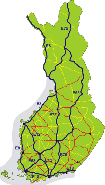
Map of all E-roads in Finland, shown in dark blue. National roads number 1–29 are red, 40–98 are yellow. Black dots show the 12 biggest urban areas.
Original: http://commons.wikimedia.org/wiki/Image:Finland_european_roads.png
File history
Click on a date/time to view the file as it appeared at that time.
| Date/Time | Thumbnail | Dimensions | User | Comment | |
|---|---|---|---|---|---|
| current | 11:59, 25 August 2013 | | 455 × 800 (120 KB) | 127.0.0.1 (talk) |
- You cannot overwrite this file.
File usage
The following file is a duplicate of this file (more details):
- File:Finland european roads.png from Wikimedia Commons
The following page uses this file: